
Anyone who has ever visited Birmingham, Alabama is familiar with the Vulcan statue and museum that sits atop Red Mountain. What they might not be familiar with is the gorgeous neighborhood that shares the top of Red Mountain with him. This neighborhood is called the Red Mountain Suburbs. It was built between 1911-1935 and is the state's second oldest fully-realized, garden-landscaped residential area. It is situated on the slopes and crest of Red Mountain which provides spectacular views of the city below.


The Red Mountain area is made up of several real estate developments spanning the years between 1911 and 1935. Although each of these developments was originally planned as a separate entity, they collectively embody the same general feeling of design with similar architectural and landscaping features that unify the area. The overall design is based on a single curving street along the edge of the mountain crest from which a number of winding streets and cul-de-sacs radiate into the surrounding natural woodlands. Along one portion of the street skirting the edge of the crest is a park. Another small circular park near the center of the crest, called Key Circle, provides a formal entrance to the area and is a major intersection for the main access streets. Many of the streets cut deeply into the slopes and the resulting banks are reinforced with high walls of natural stone. The majority of the houses are the largest and most impressive homes in Alabama. They comprise the finest examples of Tudor, Classical Revival, Dutch Colonial, Spanish Revival, Renaissance Revival, English Cottage and Chateauesque domestic architecture in the state. The houses are situated on large lots, some encompassing several acres, and are shaded by enormous trees, most of which are a part of the natural vegetation of the mountain. Many of the estates retain their original servant and guest houses.


The district is comprised of 379 homes with approximately 100 contributing garage buildings and 3 special park features. The boundaries of the district have been drawn to encompass the largest concentration of housing within the Valley View, Milner Heights, Altamont/Redmont Drives and Redmont Park subdivisions from the original (early 20th century) plats of these exclusive and upper middle class suburban neighborhoods.


The Red Mountain Suburbs in Birmingham contain Alabama's finest collection of residential architecture built between 1911 and 1935 and include the state's best examples of the domestic use of the Tudor, Spanish Revival, Chateauesque, Classical Revival, Dutch Revival and Colonial Revival. In the district are some of the best designs by the city's most noted architects — John Miller, Hugh Martin, Warren, Knight & Davis, as well as designs by landscape architect George H. Miller of Boston and architect Richard Johnson of California. Criterion C - Landscape Architecture; The Red Mountain Suburbs (1911-1935) are significant as the second of Alabama's two fully-realized examples of garden-landscaped residential suburbs popularized in the United States by Frederick Law Olmsted in developments such as Druid Hills (1893) in Atlanta and Riverside (1869) in Chicago, Utilizing the natural contours of the crest and north slope of Birmingham's Red Mountain, the district features scenic overlook drives relieved by curving cul-de-sacs. The district encompasses four separate residential developments: Valley View (1911); Milner Heights (1914); Redmont/Altamont (1914) and Redmont Park (1925).


The developments, however, are harmoniously bounded by the similar landscape designs utilizing the natural topography and native foliage. Drawing from the plans of landscape architects C. W. Leavitt of N.Y. (Milner Heights, 1913-14 and the Woodward Estate, 1919, Inv. #278 grounds) and George H. Miller of Boston (Valley View and Altamont Road, 1911-19), as well as Birmingham landscape architect William H, Kessler and engineer John Glander (Redmont Park, 1925) , the district incorporates almost every conceivable precaution to guard against undesirable encroachments, preserve property value, provide natural environmental beauty and reflects the position and wealth of its residents. Criterion A - Urban Planning; The Red Mountain Suburbs is an exceptionally good example of the automobile suburb. Sited two hundred feet above the nearest streetcar stop, the district reflects the transportation transition to the private automobile during the early 1920s as Birmingham's affluent sought refuge from the pollution of the city's heavily industrialized areas.


The developments, however, are harmoniously bounded by the similar landscape designs utilizing the natural topography and native foliage. Drawing from the plans of landscape architects C. W. Leavitt of N.Y. (Milner Heights, 1913-14 and the Woodward Estate, 1919, Inv. #278 grounds) and George H. Miller of Boston (Valley View and Altamont Road, 1911-19), as well as Birmingham landscape architect William H, Kessler and engineer John Glander (Redmont Park, 1925) , the district incorporates almost every conceivable precaution to guard against undesirable encroachments, preserve property value, provide natural environmental beauty and reflects the position and wealth of its residents. Criterion A - Urban Planning; The Red Mountain Suburbs is an exceptionally good example of the automobile suburb. Sited two hundred feet above the nearest streetcar stop, the district reflects the transportation transition to the private automobile during the early 1920s as Birmingham's affluent sought refuge from the pollution of the city's heavily industrialized areas.

The October 1929 collapse of Wall Street and the subsequent Depression nearly halted the south suburban movement on Red Mountain. Harder hit than many cities in the state because of its heavy dependence on industry, Birmingham suffered massive unemployment and labor unrest. Only an occasional home was built during the 1930's, but many changed hands at severely depressed prices. Economic recovery and stability did not resume until the 1940's, as the Birmingham industries joined in the lucrative nationwide armaments production and war support effort. As prosperity gradually returned, the few vacant lots were developed. As a result, the district contains a few contemporary constructions. However, excluding these few intrusions, the district has retained its original character as outlined by its developers, and has resisted commercial service amenities often indicative of suburban development.

Major Willis Julian Milner
The success of the Red Mountain suburbs reflects the long-range vision of two Birmingham developers: W. J. Milner and Robert Jemison. Major Willis Julian Milner (b.1842), is recognized as a pioneer of Birmingham, where in 1871 his professional engineering skills were of great value in laying out the young city. In the 1880's he laid out South Highlands, but it was not until after the turn of the century, however, that he and his son, Henry Key Milner (who laid out the town of Fort Payne), developed the Milner Heights Subdivision. Robert Jemison, Jr. (1878-1974) was the son of businessman Robert Jemison of Birmingham. The senior Jemison is best known for his role in organizing the Birmingham Railway and Electric Company, and for his tenure as president of that company (which later became the Birmingham Railway, Light and Power Company). Jemison, Jr. moved to Birmingham from Tuscaloosa with his family while still a child and attended the Birmingham public schools. He later attended the University of Alabama (1895-96) and he completed his studies at the University of the South in Sewanee, Tennessee. His entry into the business world was with a Birmingham retail hardware and building supply business where he worked until 1903. That year, he organized the Jemison Real Estate and Insurance Company.

The Tutwiler Building
Among the long list of his successful ventures are the Empire Building, the Chamber of Commerce Building, the Tutwiler Building, and the Ridgely Apartments. He also built the industrial town of Fairfield and developed subdivisions including Central Park, Bush Hills, and some of the suburbs that comprise Forest Park including Mountain Terrace (NRHP 11/21/80). Jemison's company slogan, a quotation from Daniel Webster amply reflects his principles for real estate development: "Let us develop the resources of our land, call forth its powers, build up its institutions, promote all its great interests, and see whether we also, in our day and generation may not perform something worthy to be remembered." Today, the suburbs certainly exemplify Jemison's goal, as they are "something worthy to be remembered" and preserved.
One of the more infamous houses in the district is the Chaucer Hall a/k/a Swann-Coleman House a/k/a Swann Castle which is located on over 2 prime acres with spectacular views. Below are several photos of it. These photo's date from 1938 to 2003.


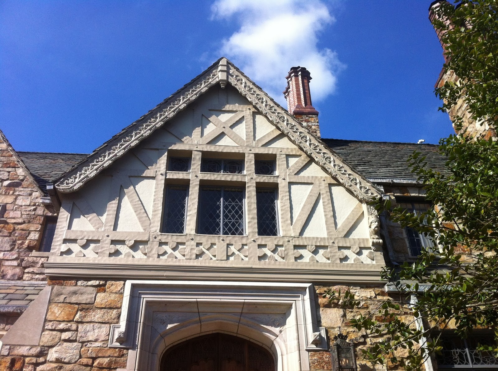

Located on Redmont Road, this property boasts eight bedrooms, eight full and three half bathrooms and is approximately 21,385 square feet. The castle was built for Theodore Swann who made his fortune as an early leader of the chemical industry.

The stones were brought to Birmingham for use in the construction of another house erected on Shades Mountain in the early 1920s. The architect was from California, and, by his representation, he obtained them from the cache of William Randolph Hearst. That house no longer stands. The leader architect on the Swann house, William T. Warren, acquired them for use in the "Norman Hall" which is a subterranean or basement room.
Swann suffered a reversal of fortune and was reduced to living in the basement of his house, trapping rabbits on the property for food. He was unable to make the last mortgage payment on the property, and, the bank foreclosed. The second owner died in an airplane crash before taking possession. The wife of the third owner went blind in the house. The fourth owners, Joseph and Virginia Simpson fared no better. the wife was found murdered in her bed, and, the husband died shortly thereafter; the fifth owners got out with any misfortune, although the husband died before the sale of the house closed. The sixth owner spent a million dollars restoring and modernizing the house; unfortunately, he, like Swann, suffered a reversal of fortune, and he sold the house at a considerable loss. The house is now on its seventh set of owners.
Several of the amenities that make this house unique are things such as a 12th-century Norman hall, preserved from an English castle. Ten fireplaces, including living-room setup with hand-carved oak paneling. Georgian dining room and stone-and-glass conservatory overlooking a pond. Small gym and two new wine cellars. Outside, an English garden with a rose arbor, a Provence garden with a pond, a kitchen garden, a dogwood grove and a boxwood parterre.
To drive through the Red Mountain District is like driving through a Hollywood movie set. Steep curving streets barely wide enough for two cars, stately trees framing the avenues and giving shade to the wondrously designed mansions whose views are beyond anything else in the city.
Red Mountain District is a unique and picturesque section of the city.


